


GREENWOOD - T 1 Voting District, Taylor County, Wisconsin
About
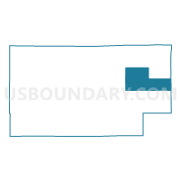
Outline

Summary
| Unique Area Identifier | 697201 |
| Name | GREENWOOD - T 1 Voting District |
| County | Taylor County |
| State | Wisconsin |
| Area (square miles) | 54.35 |
| Land Area (square miles) | 54.31 |
| Water Area (square miles) | 0.05 |
| % of Land Area | 99.92 |
| % of Water Area | 0.08 |
| Latitude of the Internal Point | 45.24499590 |
| Longtitude of the Internal Point | -90.20007390 |
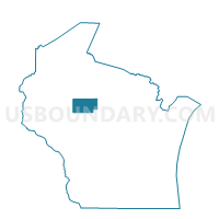
Maps

Graphs
Select a template below for downloading or customizing gragh for GREENWOOD - T 1 Voting District, Taylor County, Wisconsin


Neighbors
Neighoring Voting District (by Name) Neighboring Voting District on the Map
- BROWNING - T 1 Voting District, Taylor County, WI
- CHELSEA - T 1 Voting District, Taylor County, WI
- CORNING - T 1 Voting District, Lincoln County, WI
- GOODRICH - T 1 Voting District, Taylor County, WI
- RIB LAKE - T 1 Voting District, Taylor County, WI
- RIB LAKE - T 2 Voting District, Taylor County, WI
- WESTBORO - T 1 Voting District, Taylor County, WI
Top 10 Neighboring County Subdivision (by Population) Neighboring County Subdivision on the Map
- Browning town, Taylor County, WI (905)
- Corning town, Lincoln County, WI (883)
- Rib Lake town, Taylor County, WI (852)
- Chelsea town, Taylor County, WI (806)
- Westboro town, Taylor County, WI (684)
- Greenwood town, Taylor County, WI (638)
- Goodrich town, Taylor County, WI (510)
Top 10 Neighboring Unified School District (by Population) Neighboring Unified School District on the Map
- Merrill Area School District, WI (20,729)
- Medford Area School District, WI (14,380)
- Rib Lake School District, WI (2,673)